

Residents Evacuated As Mount Tambora Volcano Activity Increases
The status of the Mount Tambora volcano on the Indonesian island of Sumbawa has been raised to level III (Siaga) status forcing many residents in the surrounding hillsides to evacuate to lower ground.
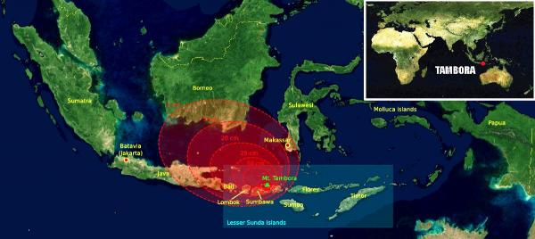
Mount Tambora, which is responsible for the largest and deadliest volcanic eruption in recorded history, started showing signs of awakening in April. But in early August, it spewed thick white smoke 20 meters (66 feet) into the sky. Seismic activity has increased significantly during September, with between 12 and 16 earthquakes being recorded on a daily basis.
An eight-kilometre exclusion zone has been set up by Indonesian authorities over fears there will be toxic gas as a direct result of the increased activity.
Hundreds of families in the villages and hamlets that lay between 5 to 10 kilometers (3 to 6 miles) from the peak have decided to move after an increase in earthquakes beneath the volcano. Some farmers, however, who have spent most of their lives living on the slopes of the volcano, remain unfazed despite the warnings from authorities.
The federal Disaster Mitigation Coordinating Agency (BNPB) also has met with leaders of the three districts surrounding Mount Tambora – Bima, Dompu and Sumbawa. Two villages, Pancasila and Doro Pet, are particularly vulnerable as they are located within 5 kilometres (3 miles) of the volcano’s peak which has a height of 4,300 meters (14,100 feet), making it the tallest in the Indonesian archipelago.
Tambora’s eruption of April 10, 1815, killed at least 71,000 and as many as 92,000 people. Around 11,000 were killed directly by the eruption and the remaining 60,000 or more died in the aftermath from starvation and disease as the eruptive fallout ruined the agricultural crops of the region.
The 1815 eruption is estimated to have had a Volcanic Explosivity Index (VEI) value of 7, the only such explosion since the Hatepe eruption in New Zealand in 180 AD and only the fifth known in human history.
The eruption caused significant global climate anomalies such as the phenomenon known as a “volcanic winter.” In 1816, Europe and North America suffered massive crop failures and the worst famine of the 19th century due to the dust and sulfur emitted by the volcano in what became known as the “year without a summer.”
Although there is a possibility that an explosion of the same scale could happen again, residents seem optimistic given that the volcano has erupted three times since 1815 but none of those events has achieved a VEI value of more than 2.
Furthermore, the West Nusa Tenggara province, where Tambora is situated, is planning a bicentenary commemoration of the eruption of the volcano. Infrastructure improvements are being carried out across the province to be completed by 2015, including the construction of a new port.
The volcanoes in Indonesia are among the most active of the Pacific Ring of Fire, an area known for frequent earthquakes and volcanic eruptions.
One of Indonesia’s most active volcanoes is Mount Merapi on Java Island which this month reported thick white smoke coming out of it. Last year, more than 300 people were killed in a series of eruptions between October and November which also displaced over 300,000 people.


One Response to Residents Evacuated As Mount Tambora Volcano Activity Increases
You must be logged in to post a comment Login


Pingback: Mount Tambora Volcano Alert Raised to Level III, Residents Evacuate | Doomtardia