
Warm and Humid Weather Here But Do We Roast?
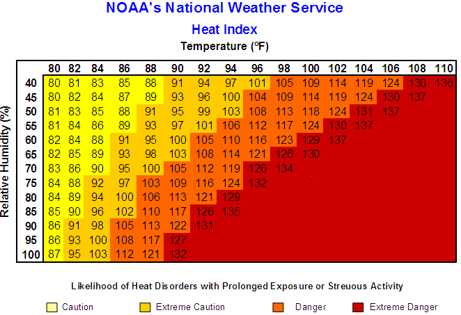
Heat Index Chart With Temps and the Relative Humidity; Courtesy of NOAA
The battle across the Ohio Valley is a classic one. Very warm to hot conditions have settled in across the central Plains and Mississippi Valley and getting as close as the southwestern part of the Ohio Valley, but farther northeast in the region the weather continues to flip flop back and forth. Every time it is about to get hot, a refreshing air mass comes in for a few days reminding us that it just cannot stay hot for too many days. Of more concern is the societal view of heat and the almost inept view some people have on the temperatures. Average highs in the middle of July are anywhere from the middle 80s to the low 90s across the region but the way some people act they act like this heat is unprecedented and unheralded. This just is not the case. What is the case is the massive amount of humidity that has filtered into the region at times this summer making conditions feel downright terrible. It is a big difference and people need to understand that. With so much global warming talk and how I feel that is complete hogwash, it is time that most understand the difference between true hot weather and just typical hazy, humid, and normal to just above normal temperatures. Again it is July and the last time I looked this is the warmest and most humid time of the year.
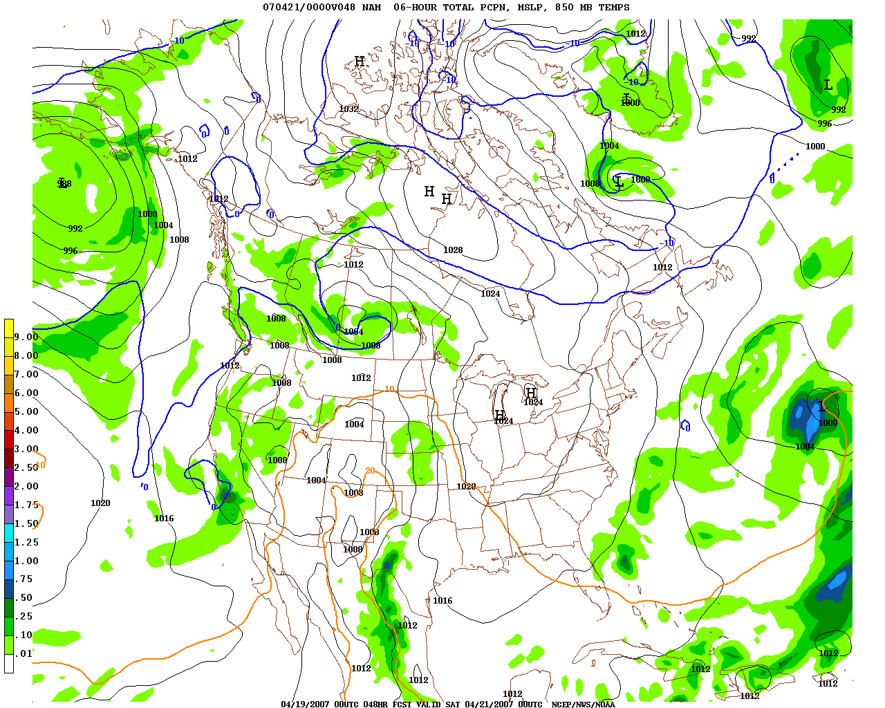
Friday Evening Upper Wind Flow Above Surface; Courtesy of NCEP
To the main topic of discussion is will the region fry this weekend into early next week? My answer is yes and no. What does that mean exactly? Well if you look at the 500 millibar chart above, it shows a ridge smack dab in the Mississippi Valley. If you travel east, the ridge axis literally splits the Ohio Valley in half. The complicated part is when winds back around to the north and northwest, thunderstorms break out because the mid levels cannot support as much heat as a place right under the ridge can.
Friday Potential Rain Coverage; Courtesy of NCEP
The result is a few thunderstorms will pop across the region tempering the heat in the northerly and northwest flow. If you look just west of here, subsidence will be great enough to prevent thunderstorm development allowing temperatures to rise.
Saturday Evening Upper Wind Flow; Courtesy of NCEP
Fast forwarding into Saturday the upper level ridge strengthens but is farther west and will once again allow parts of the region to sit and sizzle, while other parts will be very warm and humid but allow for isolated to scattered thunderstorms. In fact the high’s influence becomes strong enough to allow for northeasterly winds which can allow subtle cool to come in from the northeast and collide with the heat to the west. This has potential to lead to better storm development for the eastern sections of the Ohio Valley on Saturday.
Saturday Potential Rain Coverage; Courtesy of NCEP
As seen on Saturday evening if you are in the northerly flow then the chance of thunderstorms exist. With a typical summer time pattern not everyone will see the storms but places that do see something, very heavy rain, deadly lightning, wet microbursts, and large hail will be a threat with the cool northerly flow up top and the southerly flow at the surface. Depending on how direct the flow is from the surface to the map winds you see above training is a possibility to lead to flash flooding in selected spots.
Subtle changes will occur over the next three days and that obviously will change things on the weather front a bit but it is safe to say that the Ohio Valley will be right in the middle of a battle between torrid heat and very warm conditions. The temperature map on Friday says it all. This far out do not focus on exact temperature placement but the wide variability of temperatures based on thunderstorms.
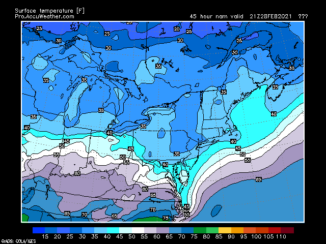
Friday Temperatures at 5PM; Courtesy of pro.accuweather,com
Under the influence of the ridge temperatures will be in the upper 80s to low 90s but where storms are located on the eastern side of the ridge temperatures hold into the 70s and low 80s.
Saturday Temperatures; Courtesy of pro.accuweather.com
Saturday is the same way. Back to the west, low to middle 90s and mainly dry but under northerly flow on the east side of the high, showers and thunderstorm activity will keep temperatures in the upper 70s to lower 80s. So to answer the question will the region roast this weekend? Yes and no. One thing though is it will be very humid.
Friday Afternoon Dew Points; Courtesy of pro.accuweather.com
Saturday Afternoon Dew Points; Courtesy of pro.accuweather.com
With dew points in the upper 60s to as high as the middle 70s, it will be rough outside. This is a good time to remember to drink plenty of water. Caffeinated and alcoholic beverages are not recommended because they actually take water out of your body and this results in your body unable to stay cool as easily and lead to quicker dehydration and heat related stress. Also, anyone who is sensitive to these elements should stay inside and away from the heat and humidity. Even healthy persons need to take it easy, as well. Stay cool out there.
By Weather Specialist Josh Ketchen
Keep it here at www.myweathertech.com for further updates.
Short URL: http://www.myweathertech.com/?p=2095


